The Hyderabad Metro is the rapid transit system that serves one of India's most important technology cities. Three fully operational lines, 69 kilometres of predominantly elevated network and 57 stations connect the residential northwest, the historic old city, the Secunderabad railway hub and the corporate IT corridor of HITEC City and Raidurg into a single coherent network.
The system opened its first 30 kilometres in November 2017 and progressively completed all three corridors by February 2020. In April 2026, the Government of Telangana acquired 100% of L&T's stake in the operating company for ₹1,461 crore — a major governance shift that converted the metro from a public-private partnership into fully state-owned infrastructure and set the stage for Phase II expansion planning.
Fares are distance-based, ranging from ₹10 (up to 2 km) to ₹60 (over 26 km). Smart card holders receive approximately 10% off all journeys. Service runs approximately 06:00 to 23:00 daily, with variations by line. The metro does not currently reach Rajiv Gandhi International Airport; that connection is planned as part of Phase II through a new Purple Line to Shamshabad.
The elevated metro that changed the urban scale of Hyderabad
The Hyderabad Metro is not just a transport network. It is a project that tried to solve simultaneously an urban mobility problem, a public-private financing model and a bet on modernising a city that had grown too fast and in too many directions. The result is one of the largest metro systems in modern India, with three operational corridors, 69 kilometres of elevated viaducts and over 500,000 daily passengers in 2024.
Hyderabad is a city of sharp contrasts. On one hand it preserves the Charminar, the historic bazaars and a cultural identity forged over centuries under the Sultanate and the Nizam. On the other it has transformed into one of Asia's great technology capitals, with HITEC City, Gachibowli, Madhapur and corporate campuses that concentrate some of the world's largest companies. The metro tries to stitch those two cities together. It does not fully succeed yet — the current network leaves out important parts of the metropolitan area — but it has already changed the way people move along the most congested corridors.
In April 2026, the Government of Telangana completed the purchase of one hundred percent of the shares of L&T Metro Rail Hyderabad Limited for ₹1,461 crore. This is not a minor administrative detail: it transforms the governance of the system, changes the decision-making structure for expansions and reorients the strategy for fare integration and multimodal connectivity.
Key system facts
| Feature | Data |
|---|---|
| Official name | Hyderabad Metro Rail |
| City | Hyderabad, Telangana, India |
| Public authority | Hyderabad Metro Rail Limited (HMRL) |
| Owner | Government of Telangana (100%, since April 2026) |
| System type | Urban metro, predominantly elevated |
| Opening year | 29 November 2017 |
| Full network | February 2020 (Green Line) |
| Operational lines | 3 corridors (Red, Blue, Green) |
| Total length | 69 km |
| Unique stations | 57 (3 interchange stations) |
| Rolling stock | Hyundai Rotem (South Korea), 57 trains × 3 cars |
| Capacity per train | ~965 passengers |
| Maximum speed | 80 km/h |
| Average speed | 35–40 km/h |
| Track gauge | 1,435 mm (standard gauge) |
| Electrification | 25 kV 50 Hz AC (overhead catenary) |
| Signalling system | Thales SelTrac CBTC |
| Daily passengers | ~510,000 (January 2024) |
| Annual passengers | ~170 million |
| Operating hours | 06:00–23:00 approx. (variations by line) |
| Fare | ₹10–60 based on distance travelled |
| Smart card | ~10% discount. ₹20 non-refundable admin fee |
| Project cost (Phase I) | ₹18,800 crore (~USD 2 billion) |
| Airport connection | Not direct — planned Phase II (Purple Line) |
| Official website | hmrl.co.in |
Why the Hyderabad Metro is special
In many cities a metro connects the centre to residential neighbourhoods. In Hyderabad it has to do something harder: link a historic city, an administrative city, a technology city and a suburban city that have spread in multiple directions without any of them being a clear centre for the rest.
Its distinctiveness rests on three pillars. The first is scale: at 69 kilometres in a single phase, Hyderabad deployed one of the largest PPP metro systems ever attempted in the world. The second is infrastructure: a predominantly elevated network over heavily congested avenues, built at record speed — though with financial pressures that defined the entire life of the project. The third, and perhaps most relevant for understanding the present, is the governance change: from the public-private partnership with L&T as the concessionaire to fully state-owned management under the Government of Telangana, completed in April 2026.
For the traveller, the metro offers something concrete: predictability in a city where surface traffic can be slow, noisy and exhausting. Air conditioning, more stable journey times, controlled access, signage in four languages. For the urban planner, it is a case study in how India is attempting to build mass transit in cities that were already saturated before the first station opened.
History of the Hyderabad Metro
A city that grew faster than its transport
Hyderabad was always an important city, but its transformation accelerated with the technology boom of the 1990s and 2000s. The creation of HITEC City, the consolidation of Madhapur, Gachibowli and Nanakramguda as corporate districts, and the arrival of multinational IT companies completely changed the urban structure. The city stopped revolving around its historic centre. It became a polycentric metropolis generating long trips in multiple directions: from the residential northwest to the technology west, from Secunderabad towards commercial zones, from southern neighbourhoods to the centre.
The Multi-Modal Transport System (MMTS), inaugurated in 2003 as a suburban rail system, proved insufficient to absorb that growth. Its coverage was limited and its capacity could not compete with the scale of the problem. The need for a real urban metro was evident long before construction began.
The PPP project: a large-scale financial bet
The metro project was conceived from the outset under a public-private partnership model. The idea was that the private sector would not only build and operate the system but also develop associated commercial opportunities: station retail space, advertising, non-fare revenues and real estate assets linked to the metro corridor.
Larsen & Toubro (L&T) won the tender in July 2010 for ₹121,320 million. It was an ambitious contract: build all three Phase I corridors, operate the system for 35 years and bear the demand risk. Total construction cost reached ₹18,800 crore by inauguration. The PPP structure made Hyderabad an internationally watched laboratory observed closely by metro project planners and financiers worldwide.
The theoretical advantage of the model was clear: accelerate investment and reduce direct pressure on the public budget. The problem was equally evident: an urban metro is not always profitable on its own, especially in early stages when demand takes years to mature and competes with cheaper and more informal transport modes.
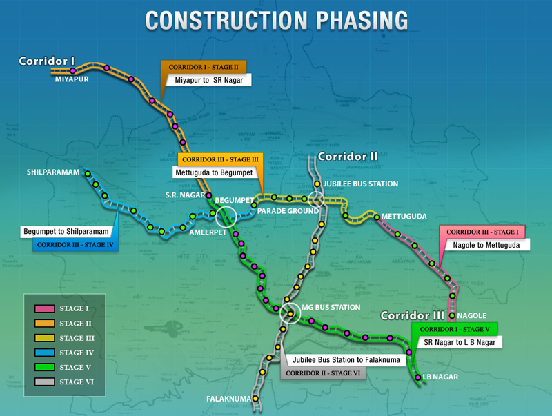
Inauguration and expansion (2017–2020)
On 28 November 2017, Prime Minister Narendra Modi inaugurated the first 30-kilometre stretch, described at the time as "the longest metro corridor opened on a single day in India's history". The system started with the initial sections of the Red Line and the Blue Line.
The network was completed section by section in subsequent years:
| Date | Section opened | Km |
|---|---|---|
| 28 November 2017 | Miyapur–Ameerpet (Red) + Ameerpet–Nagole (Blue) | ~30 km |
| 24 September 2018 | Ameerpet–LB Nagar (Red complete) | ~17 km |
| 20 March 2019 | Ameerpet–HITEC City (Blue partial) | ~10 km |
| 29 November 2019 | HITEC City–Raidurg (Blue complete) | ~1.5 km |
| 7 February 2020 | JBS Parade Ground–MGBS (Green complete) | ~11 km |
Governance change in 2026
In April 2026, the Government of Telangana completed the acquisition of 100% of L&T Metro Rail Hyderabad Limited (LTMRHL) shares for ₹1,461 crore. The transaction included the transfer of accumulated debt and the payment of an agreed amount. From that point, HMRL became an entirely public entity.
The change is not merely symbolic. It directly affects planning for Phase II expansions, fare integration with other transport modes, financing structures for new construction and the government's capacity to make decisions about the system without the constraints of the concession model. The Hyderabad PPP model demonstrated that building metro under public-private partnership in an Indian megacity is far more complex than it appeared on paper in 2010.
Construction and engineering
An elevated metro over congested avenues
The decision to build the Hyderabad Metro on elevated surface, on concrete pillars, was driven by several simultaneous reasons: lower cost than deep tunnels, faster execution, the ability to follow existing road corridors and less interference with underground infrastructure. The result is a network whose viaducts are now a recognisable feature of Hyderabad's urban landscape.
Building over already congested major avenues was complex. Construction disrupted traffic, shops and daily life along entire corridors for years. Stations, also elevated, are positioned above the avenues themselves and accessed via escalators and lifts. Otis supplied and maintains the system's 670 lifts. Twenty-three stations hold IGBC Platinum Green certification, making Hyderabad one of India's most environmentally recognised metro networks.
Rolling stock, technology and capacity
The Hyderabad Metro's trains were supplied by Hyundai Rotem, a South Korean company that won the contract for ₹18,000 million. The first units arrived from South Korea in May 2014. The current fleet has 57 three-car sets — 171 coaches in total. Each train carries approximately 965 passengers and is equipped with air conditioning, regenerative braking, passenger information systems, security cameras and automatic door opening.
The signalling and control system is the Thales SelTrac CBTC (Communications-Based Train Control), enabling close headway management with safety. Electrification uses 25 kV 50 Hz AC overhead catenary — the dominant standard for modern Indian metros. Maximum commercial speed is 80 km/h with an average operating speed of 35 to 40 km/h. In 2022 Hyderabad became the first Indian metro to deploy an ozone-based train sanitisation system; it was also the first metro in the world to offer ticket sales via WhatsApp, launched in October 2022.
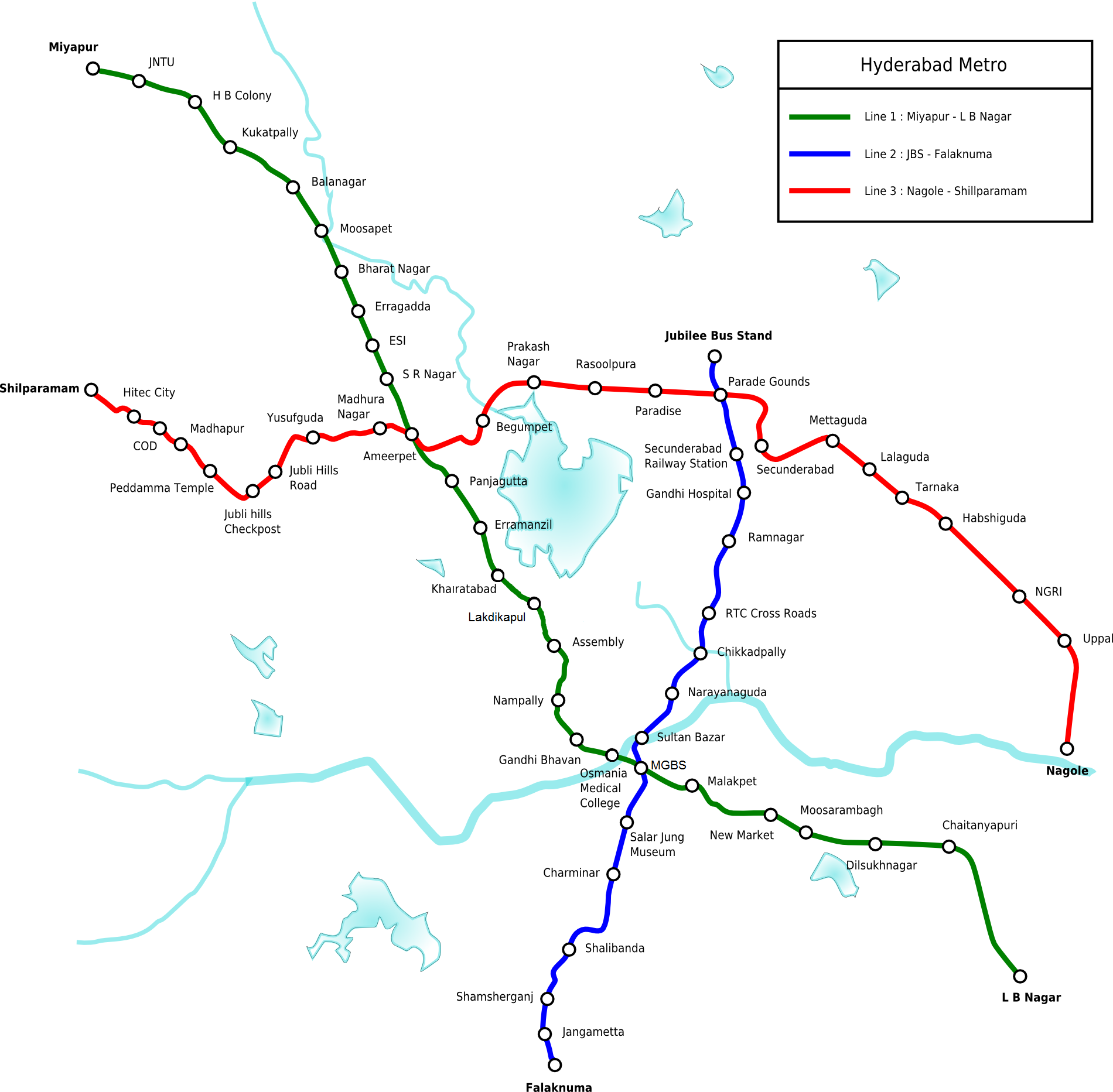
Lines and corridors
The system is organised around three colour-coded corridors sharing the same technical infrastructure, articulated at three interchange stations: Ameerpet (Red and Blue), M.G. Bus Station (Red and Green) and Parade Ground (Blue and Green).
| Line | Route | Km | Stations | Completed |
|---|---|---|---|---|
| Red | Miyapur → LB Nagar | 29.21 km | 27 | September 2018 |
| Blue | Nagole → Raidurg | 27 km | 23 | November 2019 |
| Green | JBS Parade Ground → M.G. Bus Station | 11.2 km | 10 | February 2020 |
| Total | 69 km | 57 unique* | 2017–2020 | |
* 57 unique stations on the network: interchanges Ameerpet, M.G. Bus Station and Parade Ground each serve two lines and are counted once.
Red Line: Miyapur – LB Nagar
The Red Line is the structural backbone of the system. With 29.21 kilometres and 27 stations, it runs northwest to southeast through some of the city's busiest areas: university zones in the northwest, the central interchange at Ameerpet, the administrative corridor between Khairatabad and Nampally, the major MGBS bus terminal and southeastern residential areas down to LB Nagar. It is the most useful line for commuters and for domestic travellers arriving by train at Nampally (Hyderabad Deccan) station.
| # | Station | Area and use |
|---|---|---|
| 1 | Miyapur | Northwest terminal. TSRTC bus interchange. Expanding residential area. |
| 2 | JNTU College | Jawaharlal Nehru University of Technology. High student concentration. |
| 3 | KPHB Colony | Middle-class residential neighbourhood in the northwest. |
| 4 | Kukatpally | Important commercial and residential centre. Very busy for commuters. |
| 5 | Dr. B.R. Ambedkar Balanagar | Industrial and residential zone on the northwest corridor. |
| 6 | Moosapet | Active residential neighbourhood. |
| 7 | Bharat Nagar | MMTS suburban rail interchange. Access from Lingampally and suburban HITEC City. |
| 8 | Erragadda | Residential and hospital zone. |
| 9 | ESI Hospital | Reference ESI hospital for workers. Heavily used. |
| 10 | S.R. Nagar | Active residential and commercial neighbourhood. |
| 11 | Ameerpet ★ | Red–Blue interchange. Area of private academies and training centres. Very busy at peak hours. |
| 12 | Punjagutta | Corporate and commercial zone. Hotels and offices. |
| 13 | Irrum Manzil | Area near Sanjeevaiah Park and Hussain Sagar Lake. |
| 14 | Khairatabad | Historic and administrative central zone. Access to Hussain Sagar Lake. |
| 15 | Lakdi Ka Pul | Central area. Secondary rail connection and commercial zone. |
| 16 | Assembly | Telangana State Legislature. Government buildings. |
| 17 | Nampally | Hyderabad Deccan railway station (national trains). Very useful for train arrivals. |
| 18 | Gandhi Bhavan | Telangana Congress Party headquarters. Administrative zone. |
| 19 | Osmania Medical College | Medical university campus. Dense historic area. |
| 20 | M.G. Bus Station ★ | Red–Green interchange. Major TSRTC bus terminal. Urban centre of the old city. |
| 21 | Malakpet | Historic southeast neighbourhood. Commercial zone. |
| 22 | New Market | Market and residential area in the southeast. |
| 23 | Musarambagh | Residential neighbourhood in the southeast. |
| 24 | Dilsukhnagar | Important commercial and residential zone. Very busy. |
| 25 | Chaitanyapuri | Residential neighbourhood in the southeast. |
| 26 | Victoria Memorial | Southern zone with colonial historical references. |
| 27 | L.B. Nagar | Southeast terminal. Major road and bus interchange serving southern Hyderabad. |
Blue Line: Nagole – Raidurg
The Blue Line is probably the most important for business visitors and those working in the technology sector. With 27 kilometres and 23 stations, it crosses the city from east to west through Secunderabad, the Ameerpet interchange, the Jubilee Hills neighbourhood and the corporate corridor leading to HITEC City and Raidurg. It connects the two ends of the modern urban fabric: residential neighbourhoods in the east with the major offices of the technology west.
| # | Station | Area and use |
|---|---|---|
| 1 | Raidurg | West terminal. Access to Gachibowli, Financial District and Nanakramguda. Last mile by taxi/auto. |
| 2 | HITEC City | Heart of the IT hub. Offices of major technology companies. Business hotels. |
| 3 | Durgam Cheruvu | Durgam Cheruvu Lake. High-end residential area between HITEC City and Madhapur. |
| 4 | Madhapur | Technology and residential zone. Offices, restaurants, moderate nightlife. |
| 5 | Peddamma Gudi | Peddamma Temple (western religious landmark). Residential neighbourhood. |
| 6 | Jubilee Hills Check Post | Premium residential area. Upscale mansions and restaurants. |
| 7 | Road No. 5 Jubilee Hills | Upper-class residential neighbourhood. Limited practical use for tourists. |
| 8 | Yusufguda | Residential zone in the centre-west. |
| 9 | Madhura Nagar | Active residential neighbourhood between Ameerpet and Jubilee Hills. |
| 10 | Ameerpet ★ | Blue–Red interchange. See description under Red Line. |
| 11 | Begumpet | Historic office zone. Site of former Begumpet airport (now air base). Good access to Hussain Sagar Lake from the north. |
| 12 | Prakash Nagar | Neighbourhood south of Secunderabad. |
| 13 | Rasoolpura | Secunderabad area with historic presence. Traditional Muslim neighbourhood. |
| 14 | Paradise | Commercial and dining landmark of Secunderabad. Famous for Paradise biryani restaurant. |
| 15 | Parade Ground ★ | Blue–Green interchange. Historic military parade ground and open space in Secunderabad. |
| 16 | Secunderabad East | Near the large Secunderabad railway station. Very useful for national trains. |
| 17 | Mettuguda | Quiet residential neighbourhood to the east. |
| 18 | Tarnaka | Osmania University campus. Active university neighbourhood. |
| 19 | Habsiguda | Eastern neighbourhood. Access to the National Institute of Chemical Technology (IICT). |
| 20 | NGRI | National Geophysical Research Institute. Research laboratory zone. |
| 21 | Stadium | Uppal cricket stadium. Access on match days. |
| 22 | Uppal | Industrial and residential zone in the east. Bus interchange towards the east. |
| 23 | Nagole | East terminal. Major road and bus interchange serving eastern Hyderabad. |
Green Line: JBS Parade Ground – M.G. Bus Station
The Green Line is the shortest corridor in the system, with 11.2 kilometres and 10 stations. Its route connects the Secunderabad area in the north with the major MGBS bus terminal in the centre, crossing the northern corridor of the historic city. Its importance lies more in the connections it creates than in its length: the interchange with the Blue Line at Parade Ground and with the Red Line at MGBS makes it a crucial transfer corridor for anyone crossing the city north to south.
| # | Station | Area and use |
|---|---|---|
| 1 | JBS Parade Ground | North terminal. Jubilee Bus Stand (JBS) bus terminal. Adjacent to Parade Ground. |
| 2 | Parade Ground ★ | Green–Blue interchange. Historic park and military ground in Secunderabad. |
| 3 | Secunderabad West | Western Secunderabad. Residential and commercial zone. |
| 4 | Gandhi Hospital | Gandhi Hospital, Telangana's reference healthcare facility. Hospital zone. |
| 5 | Musheerabad | Northern neighbourhood. Urban corridor between Secunderabad and MGBS. |
| 6 | R.T.C. X Roads | Major road junction between Secunderabad and central Hyderabad. High footfall stop. |
| 7 | Chikkadpally | Northern neighbourhood. Commercial and residential zone. |
| 8 | Narayanguda | Residential and services neighbourhood north of the old city. |
| 9 | Sultan Bazaar | Historic market area. Near Koti and traditional commerce. |
| 10 | M.G. Bus Station ★ | Green–Red interchange. Major Mahatma Gandhi bus terminal. Urban centre. |
Most important stations
Ameerpet — the main urban interchange
Ameerpet is the most strategically important station on the network. It is the only point where the Red and Blue Lines cross, making it the primary transfer hub for any journey that involves changing corridor. The area is known for its private academies and training centres for IT, administration and languages, generating constant demand from students and young professionals. The atmosphere is intense, noisy and very urban. At peak hours it can be extremely crowded. Practical tip: allow extra time for the interchange and avoid rush hour if travelling with luggage.
M.G. Bus Station — the link to regional buses
MGBS is the connection point between the metro and Hyderabad's largest bus terminal. It serves as an interchange between the Red and Green Lines, making it crucial for travellers arriving or departing by bus to other cities in Telangana and Andhra Pradesh. It is useful for regional travellers but not particularly comfortable as a tourist destination in itself. The Indian bus terminal can be chaotic for the uninitiated: allow extra time to move between the metro platform and the bus departure point.
Secunderabad East — the gateway to national trains
Secunderabad is one of the great railway hubs of southern India, with trains to Delhi, Mumbai, Chennai and other major cities. The Secunderabad East metro station facilitates the connection with Indian Railways, though the distance between the metro platform and the railway tracks requires some walking or internal transfer time. It is the most practical option for travellers combining metro with long-distance trains from this terminal. Common mistake: underestimating the time needed to make the interchange at a hub of this scale.
HITEC City — the station of technological Hyderabad
HITEC City represents the heart of Hyderabad's IT hub. The station sits in the middle of the corporate district and provides access to the campuses of Microsoft, Google, Amazon, Infosys, TCS, Wipro and other leading technology companies. There are also business hotels, shopping centres and modern dining areas. Important caveat: although the metro reaches HITEC City, many corporate campuses are several minutes by auto-rickshaw or taxi from the station. The last mile remains a real challenge in this area.
Raidurg — the gateway to the corporate west
Raidurg is the western terminal of the Blue Line and the nearest access point to Gachibowli, the Financial District and Nanakramguda. It is one of the most useful stations for Hyderabad's corporate world. As at HITEC City, the distance to some office buildings means supplementing with auto-rickshaw or taxi. Those driving into the city for business can combine parking in less congested areas with the metro from Raidurg or HITEC City to avoid traffic along the technology corridor.
Nampally — access to Hyderabad Deccan train station
Nampally connects with Hyderabad Deccan railway station, one of the three major terminals in the metropolitan area. For travellers arriving or departing by train to or from southern or central India, this is the reference metro station. It also gives access to areas of traditional central Hyderabad and some nearby historic zones.
Paradise — the Secunderabad landmark
Paradise is not just a station. It is the metro stop closest to the Paradise restaurant, probably the most famous biryani in Hyderabad and an almost obligatory culinary stop for anyone visiting the city. The Secunderabad area around the station has its own commercial life and is useful for moving around the northern metropolitan city.
How to use the Hyderabad Metro
Ticket types
The system offers several payment options: a single-use physical token, a rechargeable smart card, a paper QR ticket, a digital QR ticket from authorised apps and purchase via WhatsApp (launched October 2022, the first metro in the world to offer this). Access to platforms requires passing first through a security checkpoint with baggage scanner — standard in many South Asian metros, more visible than in most European systems.
Token
The token is a single-use contactless chip. It is purchased at ticket machines in each station. The process is straightforward: select the destination station, pay the corresponding fare and collect the token. On arrival at the destination, the token is deposited in the exit turnstile.
Smart card
The smart card is the best option for those who will use the metro for more than one day. It can be recharged at ticket machines. The non-refundable administrative fee is ₹20. Minimum recharge is ₹50 and maximum is ₹3,000. The discount applied to the fare is approximately 10%. It greatly speeds up access and avoids queuing to buy a token each time.
QR and digital options
The QR ticket allows purchase from a mobile phone without needing a physical card. It is convenient for travellers who prefer to avoid ticket machines. WhatsApp ticket purchase, available since 2022, was a nationally recognised innovation. Some third-party apps also allow purchase, though it is always worth verifying they are official channels authorised by HMRL.
Signage and languages
Stations have signage in four languages: English, Telugu, Hindi and Urdu. English is always the common vehicular language and ensures that any international tourist can navigate without knowing the local languages. Passenger information displays show the next train, destination and waiting time.
Timetables and frequencies
The system operates approximately from 06:00 to 23:00 every day of the week, with slight variations by line and station. There is no night service after 23:00.
| Line | First train (approx.) | Last train (approx.) | Peak frequency | Off-peak frequency |
|---|---|---|---|---|
| Red | 06:00 | 23:00 | 4 min | 5–8 min |
| Blue | 06:00 | 23:00 | 4 min | 5–8 min |
| Green | 06:00 | 23:00 | 12 min | 12–15 min |
Exact first and last departure times vary by station. Peak demand periods coincide with office start times (08:00–10:00), end of the working day (17:30–20:00) and connections with railway stations. Ameerpet, HITEC City, Secunderabad East and M.G. Bus Station are particularly busy at those times. Weekend frequencies are slightly lower.
Fares and tickets
The Hyderabad Metro uses a distance-based fare structure. The longer the journey, the higher the fare within a fixed scale. The system is straightforward: when buying the ticket, enter the destination station and the machine calculates the price automatically.
| Distance | Fare (token) | Fare (smart card approx.) |
|---|---|---|
| Up to 2 km | ₹10 | ₹9 |
| 2 – 4 km | ₹15 | ₹13–14 |
| 4 – 6 km | ₹25 | ₹22–23 |
| 6 – 8 km | ₹30 | ₹27 |
| 8 – 10 km | ₹35 | ₹31–32 |
| 10 – 14 km | ₹40 | ₹36 |
| 14 – 18 km | ₹45 | ₹40–41 |
| 18 – 22 km | ₹50 | ₹45 |
| 22 – 26 km | ₹55 | ₹49–50 |
| Over 26 km | ₹60 | ₹54 |
Note: In 2025 HMRL published a new fare chart (HMRL-New-Fare-Chart-2025). Exact updated prices should be verified at hmrl.co.in before travelling.
For context: the full journey from Miyapur to LB Nagar (almost 30 km) costs 60 rupees, equivalent to less than one euro or one dollar. The Hyderabad Metro is one of the cheapest mass transit systems in the world in absolute terms.
System rules
- Yield seats to the elderly, pregnant women and people with disabilities. Priority seats cannot be occupied under any circumstances.
- Luggage up to 10 kg is carried free of charge. From 10 to 40 kg, one rupee per kilo is charged. Maximum dimensions of any package: 65 × 45 × 25 cm.
- The token must be used within 29 minutes of purchase. After that time, a new one must be bought.
- Maximum time allowed inside a station is two consecutive hours, even for smart card holders.
- All types of weapons, kerosene, chemicals and explosives are prohibited.
- Smoking and eating on platforms are prohibited.
Accessibility
Hyderabad Metro stations have lifts and escalators to facilitate access from street level to platforms. The system's 670 lifts are maintained by Otis. Stations have tactile pathways and Braille buttons for visually impaired passengers. System design incorporates accessibility standards for people with reduced mobility, although the real experience may vary depending on the maintenance condition of each lift at a given moment. When a lift is out of service at an elevated station, access for wheelchair users or pushchairs can become significantly difficult. Travellers with reduced mobility should confirm access conditions before their journey.
Safety
The Hyderabad Metro is generally perceived as a safe and orderly environment, especially compared to surface transport modes. Each station has security staff, entry baggage scanners, CCTV cameras and access control turnstiles. This visible security system is standard in South Asian metros and tends to reassure unfamiliar travellers. The most common risks are those typical of any mass transit system: watch personal belongings in crowds, take care when crossing avenues near station exits, and plan ahead for the late-night last mile if the final destination is far from the station.
Luggage, bicycles and pets
Bicycles are not accommodated as a regular feature of the system. The metro is not designed for routine bicycle transport. For suitcases or travel luggage, access is possible but it is worth avoiding peak hours and using the lifts — the escalators at elevated stations can be tricky with bulky luggage. Pets are generally not permitted except for properly accredited assistance animals.
Integration with other transport
MMTS — the suburban rail
The Multi-Modal Transport System (MMTS) is the suburban rail that connects Hyderabad with Secunderabad and various peripheral areas. Integration with the metro occurs at several stations: Bharat Nagar (Red Line), Begumpet and Parade Ground (Blue Line). The MMTS covers different corridors from the metro and is useful for reaching areas not directly served by the metro, especially towards the suburban west.
TSRTC buses
The Telangana State Road Transport Corporation operates the urban and intercity bus network. Integration with the metro works at major interchanges: Miyapur and LB Nagar on the Red Line, Nagole and Raidurg on the Blue Line, and especially M.G. Bus Station where metro, urban buses and long-distance coaches converge. Fare integration is limited: metro and bus are paid separately. There is no general combined pass in 2024–2025.
Indian Railways
The three major railway terminals in the metropolitan area are Secunderabad (one of the most important in southern India), Hyderabad Deccan/Nampally and Kachiguda. The most useful metro stations to connect to each are: Secunderabad East (Blue Line) for Secunderabad station, Nampally (Red Line) for Hyderabad Deccan, and the MGBS area for Kachiguda. Journey time between the metro platform and the railway tracks can be several minutes and should be factored in.
Auto-rickshaws and ride-hailing
In practice, most metro users supplement their journey with an auto-rickshaw, ride-hailing (Ola, Uber) or company transport for the final leg. This is especially common at HITEC City, Raidurg and Blue Line terminals, where the distance between the station and the actual destination can be several kilometres. Negotiating the price with the auto-rickshaw before getting in remains the norm in Hyderabad.
Airport connection
Rajiv Gandhi International Airport is located in Shamshabad, about 24 kilometres south of central Hyderabad. It is India's fifth busiest airport and was inaugurated in 2008 to replace the old Begumpet airport. The current metro does not reach the airport. The most practical connection in 2025–2026 is the Pushpak Airport Liner bus service, operated by TSRTC, which connects the airport with several metro stations: Uppal, Begumpet, JNTU College, Secunderabad and Tarnaka.
Phase II of the metro includes a Purple Line of 36.6 kilometres between Nagole and the airport (RGIA), with 24 stations and an estimated cost forming part of the ₹24,269 crore Phase 2A budget. When operational, it will be the longest metro-airport connection of any metro system in southern India.
Most useful stations for tourists and visitors
| Station | What it serves | Practical note |
|---|---|---|
| Ameerpet | Red–Blue interchange. Network hub. | Very crowded at peak hours. Allow extra time. |
| M.G. Bus Station | Bus terminal and Green–Red interchange. | Access to commercial centre and old city. |
| Secunderabad East | National trains from Secunderabad. | Walking time from metro platform to train tracks. |
| Nampally | Hyderabad Deccan train. City centre. | Useful for arrivals/departures by train from the south. |
| HITEC City | Technology hub, business hotels. | Last mile by taxi/auto to exact office location. |
| Raidurg | Financial District, Gachibowli, corporate campuses. | Additional transport needed for some destinations. |
| Paradise | Secunderabad area, famous Paradise biryani. | Culinary landmark of the city. |
| Khairatabad | Hussain Sagar Lake, historic central zone. | Lakeside walk from here or from Begumpet. |
| Miyapur | Northwest terminal. Residential area. | Useful as starting point for the full Red Line. |
| LB Nagar | Southeast terminal. Bus connections to the south. | Less useful for tourists; mainly for southern residents. |
Practical tips for travellers
- Hyderabad is not a compact city. A journey that looks simple on the map may require metro, walking and an auto-rickshaw. Always factor in the last mile.
- Use a smart card or QR ticket if travelling for more than one day. Avoids queues and speeds up access.
- Confirm the last train before going out at night. Service ends around 23:00. Missing the last metro at HITEC City or Raidurg can complicate the return.
- Avoid peak hours with luggage. Ameerpet, HITEC City and Secunderabad East fill up between 08:30 and 10:00, and between 17:30 and 19:30.
- Access avenues can be tricky. Stations sit above major road corridors. Walking across can be difficult: always use pedestrian crossings or footbridges.
- Have the destination written down or on your phone. Although signage is in English, some local names are difficult at first try.
- Getting to the airport. The metro does not reach RGIA. The Pushpak Airport Liner is the most practical option. Allow at least 45–60 minutes of margin.
- The city's most famous biryani is a short walk from Paradise station (Blue Line).
- The system's mascot is called Niz, a character inspired by the Nizams, the historic rulers of Hyderabad.
- For large groups, shared auto-rickshaws may be more efficient than the metro on some parallel corridors.
Urban and economic impact
The metro has modified mobility patterns along the corridors it serves. The Blue Line in particular has changed the way people commute to the technology hub. Land prices around key stations — Raidurg, HITEC City, Madhapur, Ameerpet — have risen significantly since inauguration. Transit-oriented development at some interchanges has generated commercial space and mixed-use projects.
However, the metro still does not fully cover the functional city. Large parts of the metropolitan area — the airport, the Patancheruvu industrial zone, the new Kokapet corridor, Medchal, Shameerpet — remain dependent on private cars, motorbikes or buses. For many Hyderabad residents the metro is still a partial option: useful for part of the journey, but requiring a combination with another transport mode.
Future expansions and projects
The Hyderabad Metro's expansion plans are large-scale and envisage two additional major phases. The Telangana Government's takeover in 2026 may facilitate coordination with urban planning and public financing of new works.
Phase II-A (76.2 km additional, 56 stations, ₹24,269 crore)
| Extension | Section | Km |
|---|---|---|
| Red Line North | Miyapur – Patancheruvu | 13.4 km |
| Red Line South | LB Nagar – Hayathnagar | 7.1 km |
| Green Line | MGBS – Chandrayangutta (towards old city) | 7.5 km |
| Blue Line West | Raidurg – Kokapet Neopolis | 11.6 km |
| Purple Line (new) | Nagole – RGIA Airport (Shamshabad) | 36.6 km, 24 stations |
Phase II-B (86 km additional, 42 stations, ₹19,579 crore)
Three new metropolitan corridors towards Medchal, Shameerpet and the so-called Future City. The DPRs for these corridors were prepared in 2025 under the HAML entity. Their development depends on financing and political prioritisation following the 2026 governance change.
The most eagerly awaited extension is undoubtedly the Purple Line to the airport. When operational, it will significantly change the arrival experience in Hyderabad for both domestic and international travellers.
Curiosities and little-known facts
- The Global Infrastructure Leadership Forum declared the Hyderabad Metro project in 2013 the largest PPP project in metro transport in the world.
- The system's mascot is called Niz: a character wearing green and red clothing with blue trousers and a sceptre, riding a flying carpet. Its name pays homage to the Nizams, the monarchs of the historic state of Hyderabad until its integration into the Indian republic in 1948–1954.
- Hyderabad was the first Indian metro to introduce an ozone-based train sanitisation system, in February 2022.
- It was also the first metro in the world to offer ticket sales via WhatsApp, launched in October 2022.
- The system reached 100 million cumulative passengers in just 671 days of operation.
- 23 stations hold IGBC Platinum Green certification, making Hyderabad one of India's most environmentally recognised metro systems.
- Hyundai Rotem, the train manufacturer, is a South Korean company — not Japanese, as is sometimes incorrectly stated.
- The first section inaugurated in 2017 (30 km in a single day) was described by the Government of India as the largest launch of metro kilometres in a single day in the country's history.
Comparison with other Indian metros
Versus Delhi Metro: Delhi has a much more extensive network (over 390 km, 12 lines), more mature and better integrated with the entire metropolitan region. Hyderabad is more representative of the large elevated PPP metro model, while Delhi combines elevated and underground sections with fully public governance from the outset.
Versus Namma Metro Bangalore: Both systems serve Indian technology cities with similar traffic and corporate expansion challenges. Bangalore has a traffic problem perhaps even more severe than Hyderabad's, and its metro network is still maturing. Hyderabad started from a more complete Phase I in terms of kilometres inaugurated.
Versus Chennai Metro: Chennai combines underground and elevated sections in a port city with a different urban structure. Hyderabad is recognisable above all for its elevated presence over major avenues, while Chennai has a more mixed infrastructure profile.
In practical terms, Hyderabad stands out for its total Phase I length and for having been the most ambitious PPP experiment in Indian metro, with all the implications — positive and negative — that entails.
Frequently asked questions about the Hyderabad Metro
Does the Hyderabad Metro reach the airport?
Not directly. Rajiv Gandhi International Airport is in Shamshabad, 24 km from the city centre. The most practical connection in 2025–2026 is the Pushpak Airport Liner bus (TSRTC). The direct metro connection — the 36.6 km Purple Line — is in Phase II plans but has no confirmed opening date.
Which is the most important station?
Ameerpet is the main interchange: the only point where the Red and Blue Lines cross. For national trains, Secunderabad East (train to Secunderabad) and Nampally (Hyderabad Deccan train) are the key options. For the technology hub, HITEC City and Raidurg.
Is the Hyderabad Metro safe?
Yes. The system has security checks, scanners, CCTV and uniformed staff at all stations. It is generally perceived as a safe and orderly environment, more controlled than surface transport modes.
How do you pay for a ticket?
You can pay with a token (single-use chip), rechargeable smart card, paper or digital QR ticket, or via WhatsApp. The token is purchased at machines in each station by selecting the destination station.
Can the metro take you to HITEC City?
Yes. The HITEC City station on the Blue Line is in the heart of the technology hub. However, many corporate campuses are several minutes by auto-rickshaw or taxi from the station. The last mile is still necessary.
What are the metro's operating hours?
Approximately 06:00 to 23:00, with small variations by line and station. There is no night service. Weekend timetables are similar but frequency may be slightly lower.
Is it useful for tourists?
It depends on the itinerary. It is particularly useful for moving between railway stations (Secunderabad East, Nampally), the corporate zone (HITEC City, Raidurg), the central interchange (Ameerpet) and some historic points such as Hussain Sagar Lake (access from Khairatabad or Begumpet). For the Charminar and the old city, the metro reaches MGBS but many monuments require additional transport.
What makes it special compared to other Indian metros?
It is the largest metro built under a PPP model in India and one of the largest in the world in that category. Its network is almost entirely elevated. In April 2026 it became 100% public following acquisition by the Government of Telangana. It was the first Indian metro with ozone sanitisation and the first in the world with WhatsApp ticket sales.
Update history
- May 2026 — Full update: operational network (3 lines, 69 km, 57 stations), governance change (Government of Telangana, April 2026), updated ridership (~510,000/day), rolling stock corrected (Hyundai Rotem, South Korea), Phase II detailed, complete station tables.
- 2018–2019 — Original article with partial inauguration data (30 km, 2 lines).